Landslide monitoring and early warning systems aim to detect slope movement and environmental conditions that may lead to failure before collapse occurs. These systems do not prevent landslides. Instead, they reduce uncertainty and support emergency response planning.
In Europe, research and deployment of monitoring technologies have been supported by scientific framework programmes coordinated by the European Commission and successor research initiatives. Modern risk management combines engineering methods, environmental data analysis, and communication planning.
This page explains how monitoring systems work in practice, which technologies are used, and what their limitations are in real-world operations.
What is the purpose of landslide monitoring?
Landslide monitoring serves three practical functions.
- Detect early signs of slope deformation
- Support warning decisions during high-risk conditions
- Provide long-term data for hazard modelling
Monitoring works best when combined with hazard mapping, engineering mitigation, and emergency preparedness planning.
One important limitation must be understood. Monitoring reduces risk uncertainty but cannot eliminate geological unpredictability.
How landslide early warning systems work
Early warning systems usually rely on threshold-based decision frameworks.
The basic workflow is simple in concept.
- Collect environmental and ground movement data
- Compare measurements with predefined safety thresholds
- Trigger alerts when thresholds are exceeded
- Activate emergency response procedures
Thresholds are typically calibrated using historical landslide events and local geological conditions.
Rainfall threshold modelling is widely used in Europe. When cumulative precipitation exceeds critical values, authorities may issue warnings.
Threshold design is technically challenging. If thresholds are too strict, false alarms increase. If thresholds are too relaxed, dangerous events may be missed.
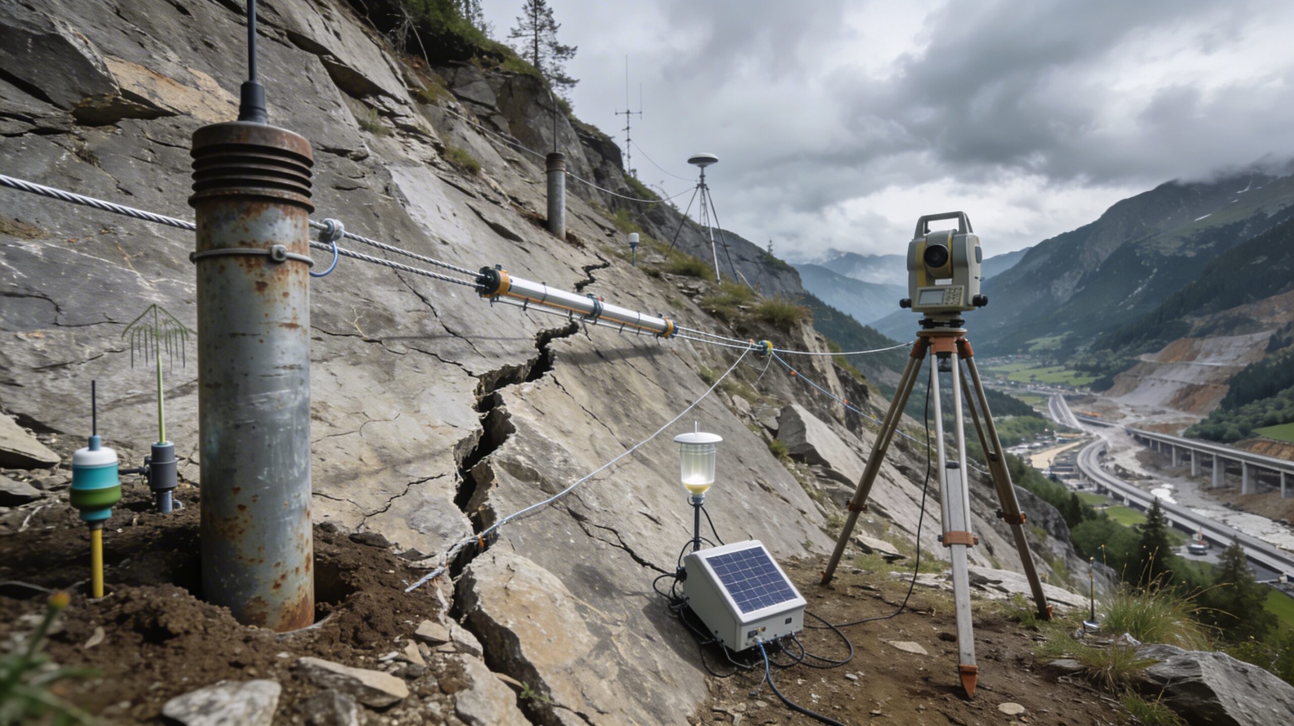
Monitoring technologies used in Europe
Modern landslide monitoring combines ground instrumentation with remote sensing observation.
Ground-Based Monitoring Instruments
Ground sensors measure physical changes inside or on the surface of slopes.
- Inclinometers – Measure subsurface horizontal movement inside boreholes.
- Piezometers – Monitor groundwater pressure that influences slope stability.
- Extensometers – Track surface deformation and crack opening.
- GNSS positioning systems – Provide high-precision displacement measurements.
- Tiltmeters – Detect small angular changes in rock or soil structures.
These instruments are often connected to telemetry networks that allow near real-time reporting.
Satellite Remote Sensing
Satellite monitoring has become a central component of European geohazard surveillance.
Interferometric Synthetic Aperture Radar (InSAR) technology can detect ground deformation at millimetre-scale precision across large regions.
Satellite observation is especially useful for:
- Mapping slow-moving landslides
- Monitoring remote mountain terrain
- Tracking long-term deformation trends
Technical limitations include atmospheric noise, vegetation interference, and satellite revisit intervals.
Ground-Based Radar Monitoring
Terrestrial radar systems provide continuous deformation tracking on exposed slopes.
These systems are commonly used near critical infrastructure, open-pit mining slopes, and steep rock faces.
Radar monitoring can detect rapid movement events, but equipment requires calibration and maintenance.
Rainfall thresholds and climate influence
Rainfall is one of the most important landslide triggering factors in Europe.
Monitoring systems often evaluate cumulative precipitation indicators such as 24-hour rainfall totals or multi-day accumulation indices.
Heavy rainfall increases pore water pressure inside soil and rock fractures. When pore pressure rises, effective stress decreases and slope stability weakens.
Climate variability may influence landslide frequency, but geological and geomorphological conditions remain the dominant controls in most cases.
Accuracy and limitations of early warning systems
Early warning systems must balance safety and operational reliability.
False Positives
A false positive occurs when an alarm is triggered but no landslide happens.
Conservative safety thresholds reduce casualties but may increase unnecessary alerts.
Missed Events
A missed event occurs when a landslide happens without warning.
Reducing missed events requires dense sensor networks and careful model calibration.
Maintenance Requirements
Monitoring infrastructure needs continuous support.
- Stable power supply
- Reliable communication networks
- Periodic sensor calibration
- Field inspection and repair
Long-term maintenance is often the most difficult operational challenge.
Who operates monitoring systems in Europe?
Monitoring programs are usually managed by national geological surveys, regional authorities, or infrastructure operators.
Methodological development and research coordination have been supported by European research frameworks, including projects related to the European Commission.
Operational deployment remains primarily a regional or national responsibility.
Difference between monitoring and prediction
Monitoring detects changes. Prediction attempts to forecast events.
Exact timing prediction of landslide failure is still not reliably possible in most cases.
Current research focuses on probability estimation and detection of precursor signals rather than deterministic forecasting.
Future trends in landslide monitoring
Research is exploring integration of artificial intelligence with sensor networks and data fusion models.
Machine learning techniques are being tested to identify deformation patterns that may precede slope failure. These methods are still developing and are not yet fully operational in public early warning systems.
Practical meaning for infrastructure safety
Monitoring systems are most effective when embedded in a broader risk management framework.
- Hazard mapping and geological assessment
- Engineering mitigation structures
- Emergency evacuation planning
- Public communication strategies
Early warning is a risk reduction tool. It is not a guarantee of safety.
Research foundations and European monitoring framework
Monitoring methodologies used in Europe have been supported by collaborative research programmes coordinated by the European Commission.
The SafeLand FP7 research project evaluated monitoring technologies and early warning system design principles.
Key technical areas studied included:
- Remote sensing observation systems
- Ground-based deformation instrumentation
- Geophysical monitoring methods
- Early warning system architecture
- Integration with quantitative risk assessment
Deliverables associated with Work Area 4 include:
- D4.1 – Detection and Monitoring Techniques
- D4.2 – Short-Term Weather Forecasting for Landslide Prediction
- D4.4 – Remote Sensing Technology Guidelines
- D4.7 – Early Warning Software Development
- D4.8 – Monitoring and Early Warning System Design
Each deliverable is summarized in the research archive section of this website.
Landslide monitoring in Europe continues to evolve as sensor technology, data analytics, and climate risk understanding improve. The main challenge is not only technical detection but also reliable decision-making under uncertainty.