Landslide risk in Europe is a persistent and geographically uneven hazard that affects infrastructure, housing, transport corridors, energy networks, and regional planning. In some countries, landslides are frequent seasonal events. In others, they occur less often but cause severe damage when they do.
This page explains how landslide risk is defined, why certain European regions are more exposed than others, how hazard maps are produced, how monitoring systems work, and how authorities manage long-term slope instability. The focus is practical understanding rather than abstract theory.
What does “landslide risk” actually mean?
The term “landslide risk” is often used loosely. In technical practice, it has a precise meaning.
Risk is not the same as hazard.
- Hazard refers to the probability that a landslide will occur in a given location within a specific time period.
- Exposure refers to people, infrastructure, or assets located in the affected area.
- Vulnerability describes how severely those exposed elements would be affected.
- Risk combines hazard, exposure, and vulnerability.
A steep, unstable slope in a remote mountain valley may have high hazard but low risk if nothing is built nearby. The same slope above a railway corridor represents significantly higher risk.
This distinction guides European planning decisions, zoning restrictions, and engineering mitigation strategies.
Where is landslide risk highest in Europe?
Landslide risk varies across Europe due to geology, climate, topography, and land use patterns.
Southern Europe
Countries such as Italy, Spain, Portugal, and parts of Greece experience frequent rainfall-triggered landslides. Steep terrain combined with seasonal intense precipitation increases susceptibility. Urban expansion into hilly terrain has increased exposure in several regions.
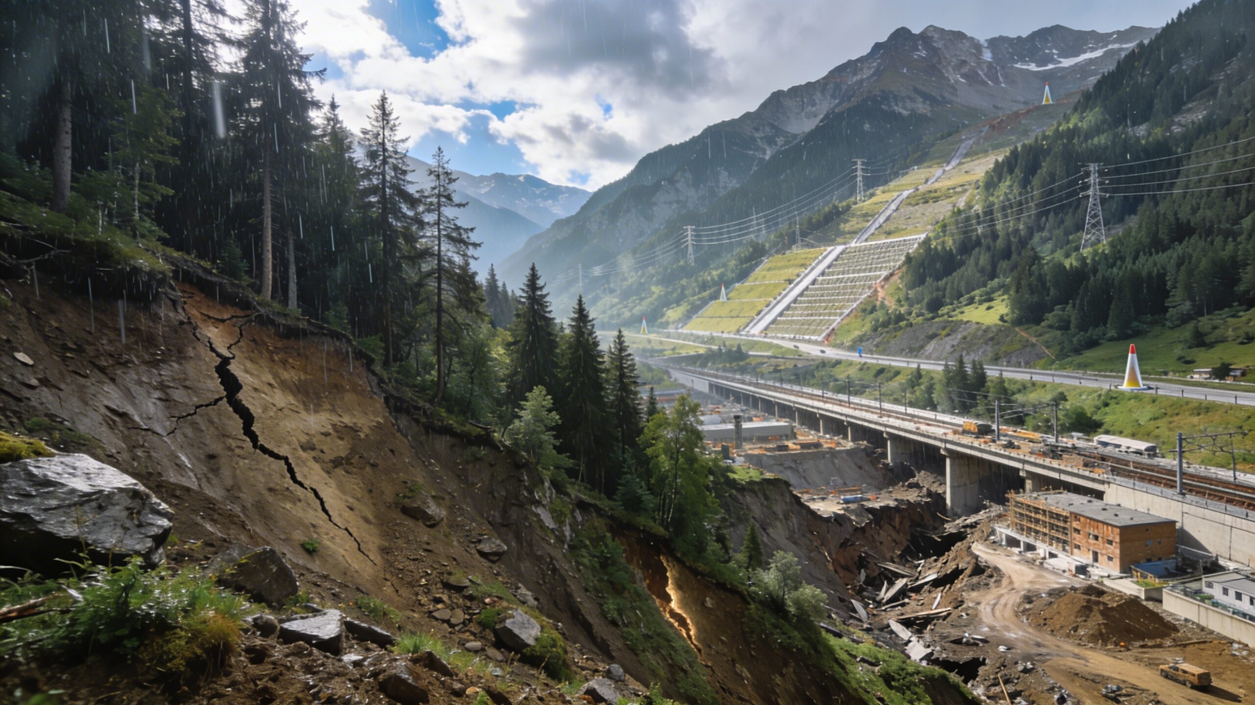
The Alpine Region
The Alps, spanning France, Switzerland, Austria, Italy, Germany, and Slovenia, face rockfalls, debris flows, and deep-seated slope instability. Permafrost degradation at higher elevations has altered rock stability in some areas.
Scandinavia
Norway and Sweden experience clay-related landslides in lowland areas as well as rock slope failures in fjord landscapes. Sensitive marine clays in parts of Scandinavia present specific geotechnical challenges.
Central and Eastern Europe
Romania, Slovakia, Poland, and parts of the Balkans face landslides associated with layered sedimentary formations and deforestation in some regions.
Across Europe, risk increases where development intersects with unstable terrain.
What causes landslides in Europe?
Landslides typically result from a combination of predisposing conditions and triggering factors.
Predisposing Conditions
- Weak or layered geological formations
- Steep slopes
- Weathered or fractured rock
- Clay-rich soils
- Historical slope movement
Common Triggers
- Intense or prolonged rainfall
- Rapid snowmelt
- River undercutting
- Excavation or construction loading
- Seismic shaking (in southern and southeastern Europe)
In many European cases, heavy rainfall increases pore water pressure within soils. Elevated water pressure reduces effective stress and lowers the factor of safety, making slope failure more likely.
How is landslide hazard mapped in Europe?
Hazard mapping is the foundation of landslide risk management. Different countries use slightly different methodologies, but the core principles are similar.
Data Collection
Hazard assessment begins with data:
- Geological maps
- Digital elevation models (DEM)
- Historical landslide inventories
- Rainfall records
- Satellite imagery
Many European countries maintain national landslide databases through geological surveys.
Susceptibility Mapping
Susceptibility maps indicate where landslides are more likely based on terrain and geological factors. These maps do not specify timing but highlight relative likelihood.
Probabilistic Hazard Assessment
Some regions apply statistical or probabilistic models to estimate return periods. For example, rainfall threshold models estimate the probability of slope failure when precipitation exceeds certain levels.
Zoning and Planning Integration
Hazard maps are translated into planning zones. These zones may:
- Restrict new development
- Require geotechnical investigation before construction
- Mandate mitigation measures
Hazard maps inform decisions but do not eliminate uncertainty. They depend on data quality and model assumptions.
How are landslides monitored in practice?
Monitoring systems aim to detect slope movement before catastrophic failure.
Ground-Based Instruments
- Inclinometers: Measure subsurface movement.
- Piezometers: Monitor groundwater pressure.
- Extensometers: Track surface displacement.
Remote Sensing
- Satellite InSAR: Detects millimetre-scale ground deformation over large areas.
- Ground-based radar: Provides near real-time slope monitoring.
- LiDAR surveys: Map terrain changes over time.
Rainfall Threshold Systems
Some regions implement rainfall-based early warning systems. When cumulative precipitation exceeds defined thresholds, alerts are issued to authorities.
Monitoring reduces uncertainty but does not provide exact failure timing. False positives and missed signals remain possible.
How is landslide risk managed?
Risk management combines structural, planning, and monitoring approaches.
Engineering Mitigation
- Drainage systems to reduce groundwater pressure
- Retaining walls and reinforced slopes
- Rockfall barriers and nets
- Soil nailing and anchoring systems
Land-Use Regulation
In some cases, restricting development is more effective than engineering reinforcement. Zoning laws may prohibit construction in high-risk areas.
Early Warning and Emergency Planning
Where mitigation is impractical, authorities rely on monitoring and evacuation planning to reduce casualties.
Risk reduction rarely eliminates danger entirely. Residual risk must be managed through long-term maintenance and planning.
How is climate change influencing landslide risk?
Climate change affects landslide patterns primarily through precipitation and temperature shifts.
- More intense rainfall increases triggering frequency.
- Warmer winters alter freeze–thaw cycles.
- Permafrost degradation destabilises high-altitude rock slopes.
Climate change modifies trigger frequency but does not replace geological conditions as the underlying cause.
What are common misconceptions about landslide risk in Europe?
“Landslides are rare events.”
In several European countries, smaller landslides occur regularly but receive limited media attention.
“Engineering can eliminate landslide risk.”
Engineering reduces probability and consequences but cannot eliminate natural variability.
“Hazard maps guarantee safety.”
Hazard zoning is based on best available data, not certainty.
What role does European policy play?
European-level research programmes have supported harmonisation of hazard assessment methodologies. However, land-use planning and enforcement remain national or regional responsibilities.
This creates variation in implementation across countries. Some regions integrate hazard data directly into digital planning systems, while others rely on case-by-case assessment.
Why understanding landslide risk in Europe requires long-term perspective
Landslide risk evolves slowly in some areas and rapidly in others. Urban expansion into hilly terrain increases exposure. Infrastructure networks built decades ago may not have been designed using modern hazard data.
Effective management requires integration of geological knowledge, engineering practice, monitoring technology, and regulatory oversight. No single discipline addresses the issue alone.
Landslide risk in Europe is neither static nor uniform. It reflects the interaction between terrain, climate, development patterns, and policy decisions. Understanding those interactions is the foundation for realistic and responsible risk management.