Conceptual Framework for Integrated Landslide Analysis
Landslide risk results from a chain of interconnected physical processes. Understanding this sequence is essential for reliable hazard assessment, early warning systems, and quantitative risk analysis.
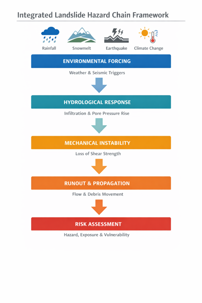
The landslide hazard chain consists of five primary stages:
- Environmental Forcing
- Hydrological Response
- Mechanical Instability
- Runout and Impact
- Exposure and Risk Quantification
1. Environmental Forcing
Environmental forcing represents the external triggers acting on a slope system.
- Intense or prolonged rainfall
- Snowmelt events
- Seismic ground shaking
- Permafrost degradation
- Climate variability and extreme weather
These drivers disturb the hydrological and mechanical equilibrium of slopes.
Related modelling framework:
D1.2 – Climate-Driven Slope Deformation
2. Hydrological Response
Environmental forcing induces subsurface hydrological changes:
- Rainfall infiltration into unsaturated soils
- Reduction of matric suction
- Rise in groundwater levels
- Increase in pore water pressure
Hydrological processes are commonly modelled using Richards equation (unsaturated flow) and Darcy flow (saturated conditions).
Related modelling framework:
D1.4 – Numerical Codes for Climate-Induced Landslides
3. Mechanical Instability
As pore pressures increase or suction decreases, shear strength reduces and instability may occur.
- Shallow translational sliding
- Rotational failure
- Progressive failure in clay slopes
- Static liquefaction in granular materials
Stability is evaluated using numerical tools such as shear strength reduction methods and coupled hydromechanical simulations.
Related modelling frameworks:
4. Runout and Propagation
After failure initiation, the displaced mass may propagate downslope.
- Runout distance depends on material rheology
- Topography controls flow paths
- Entrainment may increase mobility
- Deposition defines the impact zone
Modelling approaches include empirical methods, frictional and Voellmy-type rheologies, and depth-integrated numerical simulations.
Related modelling framework:
D1.7 – Landslide Runout Modelling
5. Exposure and Risk Quantification
The final stage transforms physical hazard into risk metrics.
- Hazard probability estimation
- Impact intensity mapping
- Vulnerability assessment
- Quantitative Risk Assessment (QRA)
Risk = Hazard × Exposure × Vulnerability
Related modelling framework:
D1.8 – Model Selection for QRA
Integrated Hazard Workflow
Environmental Trigger → Hydrological Change → Mechanical Failure → Propagation → Risk Assessment
This structured approach supports hazard zoning, early warning systems, climate scenario modelling, and infrastructure protection planning.
Role Within the SafeLand Framework
The hazard chain connects:
- D1.2 – Mechanism understanding
- D1.4 – Numerical simulation
- D1.7 – Runout modelling
- D1.8 – Risk assessment integration
Together, these components form a harmonised European framework for landslide hazard analysis.